• Premium
  • myVentusky
  • Il sito
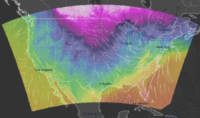
  • New High-Resolution NAM Model Now Available for the U.S. and Hawaii NAM

    稲荷橋

    稲荷橋 - Webcam
    16 minuti fa

    稲荷橋 - Ieri
    Ieri
    稲荷橋 - Oggi
    Oggi
    Confronto dell'immagine dell'ultima ora disponibile (a destra) con l'immagine di 24 ore fa (a sinistra).

    Webcam più vicine

    向台 5 km kasen-suibo.metro.tokyo.lg.jp

    6 km co.jp

    鷺盛橋 6 km kasen-suibo.metro.tokyo.lg.jp

    国分寺 9 km ac.jp

    和田見橋 9 km kasen-suibo.metro.tokyo.lg.jp

    多摩区 10 km go.jp

    Temperatura
    Temperatura percepita
    Precipitazioni
    Radar
    Satellite
    Nuvolosità
    Velocità del vento
    Raffiche di vento
    Pressione atmosferica
    Temporali
    Umidità
    Mare
    Manto nevoso
    Inquinamento atmosferico
    AvviaPrecedenteSuccessivoCambia dataOggi, 27/03/202500:0001:0002:0003:0004:0005:0006:0007:0008:0009:0010:0011:0012:0013:0014:0015:0016:0017:0018:0019:0020:0021:0022:0023:00
    lumamegivesado
    24252627282930
    31marzo010203040506
    07080910111213

    For this output data, temperature is shown for 2 m sopra il suolo. The calculations take into account the terrain (elevation), but with lower resolution than in reality. Therefore the models cannot differentiate, for instance, the temperature on a mountain peak or on a city square scorched by the sun. The general rule is that the centres of large cities are 1 °C to 3 °C warmer than the surrounding area or natural landscapes. Significant temperature differences over a small area are primarily caused in the winter by an inversion. A short yet noticeable cooling can also occur after a local summer storm.

    WebcamFronte meteorologico
    CondividiImpostazioniPremiummyVentuskyIl sito
    稲荷橋
    °C5040302520151050−5−10−15−20−30−40